MS Word Document (DOC/X)
Type of resources
Topics
Keywords
Contact for the resource
Provided by
Years
Formats
Update frequencies
-

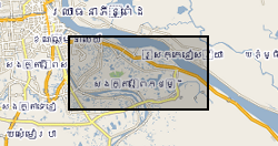
The dataset comprise hydrogeochemical, isotopic and environmental geophysics data from surface waters and groundwater and sediments from scientific boreholes drilled into arsenic-prone aquifers in the Mekong River Basin. The data is divided into 5 categories: Geophysical data Hydrogeochemical data Isotopic data Sedimentary data Outreach and Dissemination Publications to date - open access linkages The data pertain to samples obtained from northern Kandal province just south of Phnom Penh in Cambodia. The data were collected over the period 2013-2016. The hydrogeochemical data were obtained by one of more of (i) in situ analytical techniques; or (ii) instrumental geochemical techniques, notably IC, ICP-AES, ICP-MS and GC-MS in the Manchester Analytical Geochemistry Unit, University of Manchester following methods as described in Richards et al. (2015, 2017). The geophysical data were obtained as described in Uhlemann et al. (2017). The data were obtained as part of a project funded by NERC Standard Research Grant NE/J023833/1 the major purpose of which was to determine the extent to which surface derived organics may be driving arsenic mobilisation in shallow circum-Himalayan aquifers, an exemplar of which is norther Kandal Province's largely Holocene aquifers to which these data refer. The data were obtained and interpreted by the University of Manchester except as follows: environmental geophysics data were obtained and interpreted by Oliver Kuras and Sebastian Uhlemann of the British Geological Survey GTOM team; tritium data were generated by Jurgen Sultenfuss of the University of Bremen; oxygen and hydrogen isotope data by SUERC, East Kilbride and carbon-14 data by the NERC Radiocarbon Laboratory at East Kilbride.
 NERC Data Catalogue Service